I'll be keeping all of my blogging at: http://www.daysontheriver.com.
I finally got the site all updated with WordPress, so I'm back up and ready to go. Check it out there. Cheers-
JHB
Monday, March 23, 2009
Tuesday, March 04, 2008
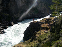
Salto Nilahue, Region X, Patagonia, Chile
Salto Nilahue was the last stop on the "Epic Patagonia Kayak Roadtrip." After 3 weeks paddling the Futa, Baker and other big rivers, the boys were fired up to run a big drop. In between Puerto Montt (where the ferry dropped us) and Temuco (where we needed to return the rental truck) lies the Salto Nilahue, the perfect end to a perfect trip.
A year and a half ago this waterfall was first run by LJ Groth and Trip Jennings as a straight 60+ foot drop. Shortly after their run the drop collapsed and has been constantly changing since. The new version was first run at the beginning of this season by Ian Garcia, Cris Korbulic and Rodrigo Tuschner. Since their new first its only been fired up by a few other crews. Tom, Phil and I ran the huge falls on Feb 23rd, 2008. Tom ran three times... it was THAT good. The first 30-35 feet are a near vertical ramp which terminates in a 30-35 foot freefall.
 Phil Caravick down the middle.
 Tom's first run, a little off.
 Tom's second, nailed it.
 Jonathan about to freefall.
The drop was the largest I've ever paddled and had a softer landing than expected. The spot is very photogenic and not too hard to get to. If you go to Rio Bueno, Chile and head east 50km to Lago Ranco, the road turns to dirt 1km past the town of Lago Ranco. Follow the road 22km and you'll see signs for the falls. We paid 800 pesos ($1.75) for access and picnic area.
Monday, February 18, 2008
Rio Baker, Region XI, Patagonia, Chile
The Rio Baker is one of the classic big water runs. With flows ranging from 20-40,000cfs, the holes, waves, seams, boils and features of this behemouth dwarf anything I have ever paddled. We guestimated a flow of 32,000cfs for our runs, although it was really hard to tell.
We arrived at the Baker after a shorter than expected 13 hour drive from Futaleufu. Our team of Tom McLay, Ben Bedingham, Phil Carrivick and myself setup camp in Puerto Bertrand (at the birth of the river) and then headed down the road to scout out the first canyon. The scouting missing revealed 4 rapids in the canyon which we anticipated running the next day.
 Jonathan scouting the second rapid.
Above the first Canyon is Salto Nef, a riverwide waterfall cascading 30 feet over two tiers and terminating in 'The Pit of Death'. There was a good sneak on the far left side which we ran.
 Tom running the sneak at Salto Nef
After the Salto Nef, the first canyon fires off three rapids back to back. The first is a big move through the middle right to avoid the monster hole on the left. The tounge on this rapid must be 20 feet deep as you plunge into the cascade.
The second rapid follows closely after the runout of the first, with a left entrance, cutting behind 'the dragons back' behind a huge lateral to the right to dodge another huge feature. Then making it back into the middle to run down the center wave/hole train to the end.

The third rapid is the most consequential, with most of the flow crashing into the right wall at the bottom. The move cuts accross from right to left. At the bottom of the first trough is a small rib that you fly past as you cut left. This single tounge is the largest I have ever seen. Standing at least 20 feet tall, you can´t see anything in the rapid once you´ve dropped down it, and the stoke of cruising up the wave face is unmatched.

We arrived at the Baker after a shorter than expected 13 hour drive from Futaleufu. Our team of Tom McLay, Ben Bedingham, Phil Carrivick and myself setup camp in Puerto Bertrand (at the birth of the river) and then headed down the road to scout out the first canyon. The scouting missing revealed 4 rapids in the canyon which we anticipated running the next day.
 Jonathan scouting the second rapid.
Above the first Canyon is Salto Nef, a riverwide waterfall cascading 30 feet over two tiers and terminating in 'The Pit of Death'. There was a good sneak on the far left side which we ran.
 Tom running the sneak at Salto Nef
After the Salto Nef, the first canyon fires off three rapids back to back. The first is a big move through the middle right to avoid the monster hole on the left. The tounge on this rapid must be 20 feet deep as you plunge into the cascade.
The second rapid follows closely after the runout of the first, with a left entrance, cutting behind 'the dragons back' behind a huge lateral to the right to dodge another huge feature. Then making it back into the middle to run down the center wave/hole train to the end.
Ben and Phil in the bottom of the 2nd rapid.
The third rapid is the most consequential, with most of the flow crashing into the right wall at the bottom. The move cuts accross from right to left. At the bottom of the first trough is a small rib that you fly past as you cut left. This single tounge is the largest I have ever seen. Standing at least 20 feet tall, you can´t see anything in the rapid once you´ve dropped down it, and the stoke of cruising up the wave face is unmatched.
 Ben dropping into the tounge on the 3rd rapid
There is a 2km break in the action before the 4th and final rapid in the first canyon.
The second canyon takes a mere 15 minutes to paddle, and has no real 'rapids'. The whole canyon is full of whirl pools and constrictions. In some ways, this is more nerve racking than the first canyon, as house-sized whirl pools open up under you at any time for no real reason. Its hard to see them coming and they suck you down further than you´d like to think. At one point, I got pulled under for5 seconds in a Pyranha G3 275, a huge boat to be logging downtime.
The second canyon ends at the orange arch bridge. Below the bridge is a great playwave/ hole with eddy service.
The third canyon is the location of the proposed site of a hydro project courtesy of Endesa, a Spanish company set on ruining Patagonia with a network of dams and powerlines headed North. Because of the likelyhood of this section of river being lost forever, paddling this section of the Baker was a main goal of our Baker Mission. The third canyon proved stunning and full of great whitewater.
The third canyon has 6 distinct rapids. The first is a massive channel full of boils and unpredictable features that come out of nowhere. Scout right.
The second rapid is a portage (at least for most). The entire Baker drops through a mess of a channel, maybe 20 feet wide, creating unfathomably big holes/whirls/seams/death... Portage left over the hill.
The third rapid is the biggest in the third canyon. The huge V shaped hole/wave caught Tom on the first run, ending in a 20 second ride/ rag-dolling in one of the largest features on the river.
The fourth rapid goes from the right, then cutting back left towards the bottom. The waves are super erradic, and you have to cut through the middle of the mess.
The fifth rapid is unscoutable and unportageable. A giant pointy rock on the right signals its approach. There is a huge hole on the left, so center to center right is best here.

Tom and Ben above the 5th rapid, next to the pointy crag.
The sixth rapid is fairly straightforward, dropping down through a few big waves and holes, cutting left to right.
The Rio Baker is a classic trip. Between its remote setting along the Carratera Austral (Southern Highway) and the huge scale of the rapids and river, it will set the bar for all bigwater trips I do from here out. A strong team is a must on the Baker as a blown skirt or swim on the river isn´t really an option. Most of the rapids are scoutable and portageable, although portaging in the first canyon would basically be a hike-out to the road. For those boater who can catch the third canyon of the baker before it is lost to the dam, get down there. For info about the damming of Chilean Patagonia, check out: http://www.patagoniasinrepresas.cl/final/
Friday, January 25, 2008
Rio Futaleufu - The Rundown
The last week on the Rio Futaleufu has been awesome. I've been able
to paddle some incredible rapids, surf huge waves, get worked in some
big holes, and not swam (yet). The backdrop for the Futaleufu is
amazing with rugged mountains, lush green forest, and some glaciated
peaks in the distance. I've been staying with Aaron and Sarah along
the Rio Azul and they have been gracious hosts at their riverside camp
(http://www.regionxrivers.com/). The days have looked like:
1/19 - Rio Espolon (slept at Treehouse)
20 - Bridge to Bridge Section with Liz (slept at Treehouse)
21 - Hitched ride to Region X at Rio Azul
22 - Rio Azul to Terminator to Bridge to Bridge
23 - Inferno Canyon to Rio Azul
24 - Rio Azul to Terminator to Bridge to Bridge
25 - day of rest
26 - Bridge to Bridge
27 - Rio Azul to Bridge to Bridge
27 - Rio Azul
28 - Rio Azul to McCall
29 - Inferno Canyon to Rio Azul
Some of the highlights include:
1) Bridge to Bridge Section: The 'B to B' section of the Futa is the
commercial day trip for the raft companies. It is a quick 10km of big
water class III-IV. There are some epic playwaves like Aquarium,
Pistola, and Rodeo Hole, with some huge rapids Mundaca, Entrada,
Tobogan, and others. Ran this a bunch and its always a good time.

2) Inferno Canyon: The Inferno is the uppermost section of the Futa.
It starts on the Rio Espolon, meets the Futa, and then drops into the
Canyon. There are five big rapids through here, and they are BIG.
Entrada, Wall Shot, Wall Shot II, Dynamite, and Exit all have narrow
lines, ass kickingly big holes and big whirlpools and boils. Entrance rapids
 Dynamite, line is down the middle
 Exit Rapid, the last of Inferno Canyon. At least 50 feet above the river.
3) The Throne Room: The Throne is the biggest rapid on the Futa.
The whole mess looks like a giant white rollercoaster that crashes
down onto a huge rock on the right side. I dropped in on the right,
but started to cut left too early, accidentally dropping into the big
hole in the middle. I went super deep, resurfaced rolling up into the
pillow on the rock at the bottom, got surfed half upright, half
upsidedown across the river and rolled up just in time to paddle hard
and go under the final hole. It was a rush.
4) Espolon Pools, The Espolon flows right next to the town of Futa, and has some great swimming holes as well as local play spots. Its also totally beautiful. I spent my first afternoon in Futa here borrowing kayaks from the locals and hanging out with my Argentine friends Laura and Sonia. So sweet.
5) Zeta: This is a seldom run rapid on the Futa. Most people portage because the risks outweigh the reward of running it. None the less, its an amazing rapid just to look at, and the bubble pool below framed by the huge boulders and blue skies can´t be beat. The Futa is a magic place and I can´t wait to stop through here again
my next time South. Logistics are hard, but the boating is amazing.
Wednesday, January 16, 2008
Hitchhiking towards real disaster on Ruta 40
Wow, where to start... the last few days have been a very intense experience.
After the last hitch hiking debacle getting caught out in Rio Gallegos, Nadia and I hopped a bus to El Calafate. Calafate was a cool but very touristy kinda place, reminiscent of Hood River in the summer. There are lots of good outdoor activities in the area, and its the main hop off city for the Glaciers National Park. The main street is lined with outdoor gear shops, cafes, restaurants, bars and tourist agencies. The locals say the place is very relaxed in the winter, when all the tourists have left and it returns to just being a quiet little town (very similar to HR!). There is also an endless amount of good ice cream and bakeries, making it a dangerous place to stay for too long.
From El Calafate we did a day trip to the Perito Moreno Glacier, the most popular of the local activities. What makes the glacier so famous is that you can stand from a viewing platform and watch the ice tumble into the lake. We saw a couple of big chunks shear which was sweet and did a boat ride in front of the glacier to get a different perspective.

After the glacier we got a bus to El Chalten, the small community that has developed around tourism around the northern part of The Glaciers Park and Mt. Fitz Roy. From the windy town, you can see Cerro Torre, an inspiring Granite Peak that towers 2000m+ over the valley. You can also see Mt. Fitz Roy, equally inspiring (if you can see it!). We arrived and stayed 3 days in the campground, with endless amounts of wind, bit of rain and lots of cold. The irregular winds were collecting clouds up around the peaks, so we never actually got to see Fitz Roy, a bit of a disappointment. We did a hike around the park, circumnavigating the area below the two peaks and the valley in between. The scenery was spectacular, with occasional views of the Torres.

From El Chalten we wanted to go to the Carretera Austral (Southern Highway), Ruta 7, in Chile, which begins in Villa O'Higgins. The only way to get there is from a water taxi that goes only on Saturday if there isn´t wind, which there always is. Apparently it goes less than once a month. We missed the boat, so we decided to try to head up Ruta 40 (the inland Argentine Highway), made famous by Che Guavera's Motorcycle Diaries, much of which was traveled on this desolate, baren, dry, dirt road in the middle of the pampa (high desert). Our plan was to travel 600km up Ruta 40 to Los Antiguos, cross the border there into Chile, and follow Ruta 7 up through Chile, hiking in San Lorenzo Mastif, Cerro Castillo, Coihayqui, Futaleufu and other spots along the way. The next bus wasn´t for 2 days, so we decided it would be better to try our luck hitch hiking, rather than waiting the extra days for the bus.
We got lucky heading out of El Chalten and got picked up quickly by a nice couple, Merlin and Marina, who own Mountaineering Patagonia (http://mountaineeringpatagonia.com/). They gave us a ride about 100km to the 40, sharing stories, mate and grease cookies (kinda like croissant cookies, only better and more addictive). They dropped us at the intersection of Ruta 40 and 23 where they were headed south to El Calafate. We got lucky again and after 20 minutes got a ride to Tres Lagos, another 40km up the road. At the intersection of Tres Lagos and Ruta 40 were 4 other hitch hikers, so we decided to wait as the gas station to try our luck asking people there. This is the last gas station for more than 300km, so anyone heading north has to stop for fuel. Seemed like a good idea.
We met a really nice group of Argentines who were headed north to their farm on the side of Lake Cardiel. They took us to that intersection and left us around 5pm. The sun was high and hot. We waited patiently for our next ride. Sitting for a while, we realized there weren´t many cars on the 40. The longer we sat, the more we realized how few cars there were. A few passed but no one made any intention of stopping. Most sped by rapidly, as if they had somewhere more important to be, or couldn´t be bothered to slow down to even see us. It was discouraging.

The sun began to set and we were stuck with the realization that we would be sleeping out in the middle of the desert. This wasn´t totally unexpected, and we had food, water, camping gear, and were okay sleeping out. At the sun set into the horizon, it was impressive the solitude we experienced. We were at least 100km from anyone or anything, surrounded by flat plans of desert dust and sand. Vegetaion was sparse and the panoramic vistas reached far into the unknown. At one point as the sun was setting, I looked around to see the sun illuminating the rain clouds to our north, the bubbly storm head to our south, the sunset to the west, and pure blue skies to the east. It was like 4 different climates surrounding our desert camp. Pretty spectacular.
The cross where we had been left off had a cement culvert under the road, and we decided to sleep under the road, rather than braving the windswept plains around us. The breeze was stiff, strong enough to keep a tent rocking to its ebb and flow all night. Our culvert was lined up perfectly East-West, so we had a sunset view from the window. The road also lined up that way, giving way to some wild shadow photos as our dark spaces climbed up the road toward the horizon, getting taller as the sun got lower.
 Around 11:45pm it got really dark, and the temperature dropped to a cooler, 40s farenheight. This wasn't so cold, but it was quite windy, so we blockaded the end of the culvert with out backpacks. The night wasn't so bad, but it was short, maybe 6 hours. The sun set in front of our tunnel and rose 6 hours later 80 or 90 degrees to the left of the tunnel, not making it all the way east for the sunrise.
We started hitching around 8am and we were optimistic. As 8am turned to 10am, we still hadn´t seen any cars. After 10am we saw a few, mostly full of people, not interested in the two people sitting in the middle of the desert so early in the morning. Some waved, some began to slow down and then sped up, but mostly, not a single car stopped fully.
Around noon we began to worry. The sun was getting high in the sky, powerful and hot. The wind also began to blow again, washing dust up into our eyes. We could see cars coming from miles away, spotting the small tail of dust blowing across the horizon. Heat waves distorted the horizon, dissapearing up into the long blue sky. We watched clouds rise, cross the 180 degree panorama and fade into the distance. We were there for a vey long time.
We were getting low on water, so we began waving arms holding a water bottle, hoping to stop someone who had a bit of water. Most of the cars didn´t understand or didn´t care. We could have been lying there on the side of the road dead and I don´t think they would have stopped.
Around 4pm a overland transit vehicle (like a big truck, only full of people with a few windows) turned at the lake and headed off into the distance. A few hours later we saw two bicycles heading down the road towards us. It was an interesting encounter. They couldn´t believe we were there, and the could have been a mirage. They were from the overland tour and had gotten stuck in the sand at the lake. They were riding the 40km to a small farm on the other side of the lake to get a truck to help them out. We explained our situation and they said they would pick us up if they got out that night; not likely. So we waited.
It was difficult waiting, not sure if you could expect anyone or no one. At what time do you call it a night and go to sleep when you NEED a ride. We waited till darkness, around midnight and were about to call it a night and hunker down in the culvert for another windy, desert night. As we were discussing our options, we saw lights coming down the road from the lake. It was the overland truck, unstuck and headed our way.
They took us all the way back to El Calafate, where we began our trip a week earlier. It was a great relief to be back into civilization with food, water and shelter. Out of the desert. Although our situation didn´t become serious, it could have, easily. We were well prepared with food, water, shelter, but in a harsh and unpredictable climate, these kind of provisions only mean so much. It was disheartening to see all the cars passing, as if no one cared if we were there or not. We became part of the landscape, another things to drive past without a second glance. Not really people.
Now that I´ve put my time in on Ruta 40, I think I´m going to bus back up towards Futa and catch a few weeks of boating before heading further north towards Mendoza, Cordoba, and Buenos Aires.
Thursday, January 10, 2008
Hitching towards disaster in Rio Gallegos...
It turns out that the next great adventure was right around the corner...
Once we got off the Sierra Valdivieso we needed to get back to Ushuaia (13km down Ruta 3). We tried to hitch but there wasn´t much traffic at 9am. So we started to walk down the highway, waiting for a ride to pick us up. About a km down the road we stopped a colectivo that gave us a ride back to our hostal for US$3 each. We got some stuff together, repacked our bags, picked up our stuff from the Refugio del Mochillero (thanks to Sebastian, Fernando and crew) and headed out to hitch to Rio Grande or as far as we could make it.
We walked a few blocks towards the edge of town where we tried to get a ride. After 15 minutes a van picked us up and took us to the real edge of town. Here, at the sign claiming, 'Welcome to the Southernmost City in the World!' we awaited the next ride. In short time we got picked up by Ricardo, an amiable truck driver carrying air conditioning units from Korea that had arrived at the port. He was taking them to Rio Grande, some 200km from Ushuaia. He took us all the way there, which was great. In between his sentiments about the government, Che Guavera, and crossing himself every time we passed a cross or place where he knew a trucked who had died there in an accident, he was a really smooth ride for us.
He brought us to the warehouse laden edge of Rio Grande where we began to walk towards town. A few minutes later a taxi stopped to solicit his services, and we asked to be taken to the other side of town. For US$6 he took us all the way to the far side of Rio Grande, next to the beach. He said all the trafic would be passing through headed to San Sebastian, the border with Chile where we would need to cross to get off of Tierra del Fuego and back onto the continent.
We waited a while, ate sandwiches, waited some more, and finally got picked up by a very friendly, larger man with dark skin and no teeth named Oscar. Oscar was headed to northern Argentina, maybe 26 hours north of where we were headed. His mother had passed away that morning and he was rushing home for the funeral. Normally people fly, but since it is imposibble to get a flight out of Ushuaia (which is why we were hitching in the first place!), he was driving home for the funeral. He agreed to take us to Rio Gallegos, roughly 500km from Ushuaia, which is way further than we expected to get that day! We were smooth sailing all the way to the mainland.
Oscar was a very fast driver, rarely letting the speedometer drop below 140kph. This was good becuase we got there fast, but didn´t get a chance to relax very much. To get to Rio Gallegos from Ushuaia, you need to cross the border into Chile (exit Argentina, enter Chile), cross Punta Delgada across the Straight of Magellan, cross the border into Argentina again (exit Chile, enter Argentina) and drive another 150km to Rio Gallegos. Oscar helped with all of this and we made it to RG around 11:30pm. We were feeling good, even though he dropped us off outside of town.
We walked into town, maybe 2km, which was quite an effort considering we were carrying everything we owned. We started asking at each hotel we saw if we could stay, but suprisingly they were all full. We figured there would be more downtown, so we kept walking and kept asking, to no avail.
When we got downtown, we were worked. IT was close to 12:30am, we had been hiking at 6:30am, made it back to Ushuaia and then to Rio Gallegos and all we wanted to do was rest a bit. Every place we went to was sorry, and sent us to the next place. After 10 hotels, we had had enough, and decided to convince the hotel people to let us sleep wherever we could. The conversation went like this:
Jonathan: Estas completo, verdad? (You´re full, right?)
Hotel: Sì. (Yes)
J: Estamos muy consados y caminamos todo el dia, tienes algun lugar donde puedimos descansar? El sofà? (We're really tired and just walked all day. Don´t you have any place where we can rest, maybe that sofa?)
H: No. (No.)
J: Tenemos carpa, bolsa a dormir, todo! Por favor? El jardin es tan bonito? (We have a tent, sleeping bags, everything! Please? The garden looks nice?)
H: No. (No.)
J: Sabe donde podimos preguntar? (Do you know where we can ask?)
H: La comissaria. (The police station)
J: Gracias por nada. (Thanks, ass.)
So that was about it until 3am when we gave up. We caught a taxi to the bus station where we were sure we could sleep, at least lay down for free. As soon as we rolled up to the bus station, it all made sense! The entire bus station was FULL (really, full) of people, sleeping on the benches, floors, corners, phone booths, the whole place. Every backpacker in the city was there. I´ve never been so relieved to sleep on the floor of a bus terminal. And so we rested.
Once we got off the Sierra Valdivieso we needed to get back to Ushuaia (13km down Ruta 3). We tried to hitch but there wasn´t much traffic at 9am. So we started to walk down the highway, waiting for a ride to pick us up. About a km down the road we stopped a colectivo that gave us a ride back to our hostal for US$3 each. We got some stuff together, repacked our bags, picked up our stuff from the Refugio del Mochillero (thanks to Sebastian, Fernando and crew) and headed out to hitch to Rio Grande or as far as we could make it.
We walked a few blocks towards the edge of town where we tried to get a ride. After 15 minutes a van picked us up and took us to the real edge of town. Here, at the sign claiming, 'Welcome to the Southernmost City in the World!' we awaited the next ride. In short time we got picked up by Ricardo, an amiable truck driver carrying air conditioning units from Korea that had arrived at the port. He was taking them to Rio Grande, some 200km from Ushuaia. He took us all the way there, which was great. In between his sentiments about the government, Che Guavera, and crossing himself every time we passed a cross or place where he knew a trucked who had died there in an accident, he was a really smooth ride for us.
He brought us to the warehouse laden edge of Rio Grande where we began to walk towards town. A few minutes later a taxi stopped to solicit his services, and we asked to be taken to the other side of town. For US$6 he took us all the way to the far side of Rio Grande, next to the beach. He said all the trafic would be passing through headed to San Sebastian, the border with Chile where we would need to cross to get off of Tierra del Fuego and back onto the continent.
We waited a while, ate sandwiches, waited some more, and finally got picked up by a very friendly, larger man with dark skin and no teeth named Oscar. Oscar was headed to northern Argentina, maybe 26 hours north of where we were headed. His mother had passed away that morning and he was rushing home for the funeral. Normally people fly, but since it is imposibble to get a flight out of Ushuaia (which is why we were hitching in the first place!), he was driving home for the funeral. He agreed to take us to Rio Gallegos, roughly 500km from Ushuaia, which is way further than we expected to get that day! We were smooth sailing all the way to the mainland.
Oscar was a very fast driver, rarely letting the speedometer drop below 140kph. This was good becuase we got there fast, but didn´t get a chance to relax very much. To get to Rio Gallegos from Ushuaia, you need to cross the border into Chile (exit Argentina, enter Chile), cross Punta Delgada across the Straight of Magellan, cross the border into Argentina again (exit Chile, enter Argentina) and drive another 150km to Rio Gallegos. Oscar helped with all of this and we made it to RG around 11:30pm. We were feeling good, even though he dropped us off outside of town.
We walked into town, maybe 2km, which was quite an effort considering we were carrying everything we owned. We started asking at each hotel we saw if we could stay, but suprisingly they were all full. We figured there would be more downtown, so we kept walking and kept asking, to no avail.
When we got downtown, we were worked. IT was close to 12:30am, we had been hiking at 6:30am, made it back to Ushuaia and then to Rio Gallegos and all we wanted to do was rest a bit. Every place we went to was sorry, and sent us to the next place. After 10 hotels, we had had enough, and decided to convince the hotel people to let us sleep wherever we could. The conversation went like this:
Jonathan: Estas completo, verdad? (You´re full, right?)
Hotel: Sì. (Yes)
J: Estamos muy consados y caminamos todo el dia, tienes algun lugar donde puedimos descansar? El sofà? (We're really tired and just walked all day. Don´t you have any place where we can rest, maybe that sofa?
H: No. (No.)
J: Tenemos carpa, bolsa a dormir, todo! Por favor? El jardin es tan bonito? (We have a tent, sleeping bags, everything! Please? The garden looks nice?)
H: No. (No.
J: Sabe donde podimos preguntar? (Do you know where we can ask?)
H: La comissaria. (The police station)
J: Gracias por nada. (Thanks, ass.)
So that was about it until 3am when we gave up. We caught a taxi to the bus station where we were sure we could sleep, at least lay down for free. As soon as we rolled up to the bus station, it all made sense! The entire bus station was FULL (really, full) of people, sleeping on the benches, floors, corners, phone booths, the whole place. Every backpacker in the city was there. I´ve never been so relieved to sleep on the floor of a bus terminal. And so we rested.
1/6-1/19 - Sierra Valdivieso Circuit, Tierra del Fuego, Argentina
 The reflection of Monte Olivia on Lago Argo Iris (Rainbow Lake)
 1/6 - Ruta National 3 to Refugio Bonete to Salto del Azul, 18.5km, 10 hours
We began this circuit with a few interesting circumstances. I wanted to go and do the trek, but didn´t want to do it alone. I met two Israelis (Oshri and Pleiah) who also wanted to do the trek, but couldn´t leave until Sunday because of Shabbat. Additionally, the Israelis had bought a bus ticket to leave Ushuaia on Wed, making the normally 4 day trek into a forced 3 days. The book said this would be possible, mostly because the first day is really only 4.5km to the Refugio, a short day at the least. I ended up doing all the shopping because they couldn´t shop on Shabbat, which was fine, but made things a bit difficult, making decisions for the group without their input. We had a small planning session, but Israelis don´t really plan the way American´s do, and when the plan isn´t to have a real plan, that doesn´t work well for me. So I made a plan according to my plans.
The night before leaving I got an email from a French-Canadian girl staying at the same hostel who had seen my posting about people to do the trek. We met and decided she should forgo the Tierra del Fuego National Park for this trek; a wise decision on her part as the trek was much more impressive than the park. I was also glad to have someone else to talk with in English (although French is her first language) and someone with North American sensibilities. It was a bit of a relief to have a fourth.
The group of four met at 10:30 and got a ride with a colectivo to 17km out of Ushuaia at the trailhead. From the beginning, I though we were starting late (especially for a day where we had two mountain passes!) but the group was sure we could make good time and get over the passes. The track was easy to find, but after 30 minutes, it was obvious that the 'trail' was disintegrating into low alpine forrest without markers. We had a topo (1:50,000) and compass, so we figured we could navigate our way out of anything.
We wandered mostly lost through the lower forest for close to 3 hours to cover the first 4.5km of the track. We walked up, down, north, south, did circles, were mostly lost. Oshri was convinced that we could find the Refugio and that was very important so we could know the exact spot we were at on the map. Finding the small cabin was much like finding a needle in a haystack blindfolded, and we never did find it. Eventually we gave up on it in favor of heading into the valley towards the first pass.
Up the valley we saw it turn left and we followed the small stream up the valley. The directions said to follow the valley, but there was a large hill in our way, and we weren´t sure if it was the valley in front of or behind the big hill. This was nerve racking and we consulted the topo every five minutes or so to try to ascertain our exact locale. This was Patagonia navigation hell, with poorly contoured maps, vague directions, and pressing night time. Fortunately the sun doesn´t set in southern Patagonia until 11pm, but I wasn´t really interested in pushing these limits. We chose to go in front of the hill, and in the end the hill ended and we were in the same valley as the other lead to. Go figure.
At this juncture, we were surrounded on all sides by stellar, glacier cut valleys and steep granite walls. In front of us, the first pass, Paso Beban Este (830m) appeared, a small afterthought of the dramatic mountains towering thousands of feet up.
We got to the top of the first pass, a steep climb up shale and snowfields. There was totally amazing geology with big pieces of shale, granite, lots of quartz and rose quartz, and a very waxy green mineral.
Then we crossed a high scree field across a caldera to reach Paso Beban Oeste (850m), a windy pass looking down the valley towards the Rio Torito Valley and other high peaks. We descended rapidly, starting our decent around 7pm. We passed some beaver dams along the way, creating cascades and pools as we headed down into the valley. Around 8:30 we decided to camp, about 30 minutes short of our destination at Salto Azul.
1/7 - 30 minutes above Salto del Azul to Valley Carbajal, 16km, 8 hours
We broke camp late, around 11:30, another late start. It is really difficult to get the momentum in the morning when its cold, and has been raining a lot. Everyone was cold and getting the group going took some doing. Once we got hiking, we had to follow the river down for 30 minutes to Salto del Azul, then along river for another 1.25km before heading back up the valley towards the Laguna Azul and the next pass. We started to climb a bit early and got really lost. I didn´t think we had gone far enough down the valley to be climbing and the map looked like we were still short of the trail. After climbing for an hour through very thick brush, trees and streams, we got back to the river. We headed downstream in search of the supposed trail, but were unable to find it. Frustrated we headed back up the valley towards the waterfall, completing a big circle of maybe 4-5km. This loop brought us back to where we started around 1:30pm. From here we decided to climb up the valley again, this time heading due south up the steep valley walls. We finally got high enough to orient ourselves in the valley around 2:30pm, but the fog and clouds were so dense, that it was very difficult, if not impossible to navigate.
We continued south and up the valley, resting frequently because of the inclination of the slope. in places, we were climbing 45-60 degree rock and dirt up the valley. We got glances of the surrounding mountains, but couldn´t figure out exactly where we were. Around 4:00pm I decided that we were going to go until 5pm, and if we were still feeling lost we would descend the 600m or so we had climbed from the river and go back to where we had camped the night before. It was a harsh reality, but we couldn´t be starting the crossing at 6pm with 4-5 hours of hiking to be done. I wasn´t willing to take that risk.
We were headed up in search of the Laguna Azul, which was very impossible to find. We came across some small ponds, but nothing that would warrant a Laguna. As we neared a high summit, I said we should go to the top of the ridge, thinking we might have missed the laguna and that this was the pass. We headed up, but at the ridge line, it was clear that we hadn´t found the pass. Regretfully, we began to head down towards the river valley, resigned to the fact that we weren´t going to finish the trek as planned. We stopped to take photos of the cloud-filled valley, joking that we were less than a few hundred meters from the Laguna and couldn´t see it, or that the small, pathetic looking boggy pools below were the Laguna Azul.
As we descended, the sun broke for a second, the clouds cleared, and as I looked north up the valley, I saw something blue. Very blue. It was the Laguna, less than 200m across the ridge. We had found it. We triumphantly traversed the scree slope, heading to the Laguna around 5pm, right at the cutoff time. From the laguna, we could see the pass and the sun was shining. We decided to go for it. Reaching the Paso Mariposa was a trip highlight. From the pass we had a high view of the surrounding mountains, the Laguna Azul and its smaller counterpart, the 4 lakes on the other side of the pass. It was magic.
We glisaded down the scree on the back side toward the Lago Capullo, more than 500m below. We reached an early camp aside the Lake around 7:30pm amongst some large boulders. About 30 minutes later we were treated to a rainbow over Lake Capullo as we made dinner. We stopped 2 hours short of our Camp in the Valley Carbajal as we were all totally worked from the day. I think we walked more than 20km with more than 1500m vertical. It was an exhausting day.
1/8 - 2 hours short of Valley Carbajal to Ruta 3, 16km, 12 hours
We left camp early this day and headed straight back up the valley wall toward the Paso Valdivieso. There was again some discrepancey about which direction we needed to head this morning, but it was pretty clear after close inspection of the Topo and compass. We needed to head south away from the Kami Lake, and from the ridge it was clear which way we needed to go around a large rocky mountain/ ridge. Around 9am we reached a high rib overlooking the 5 lakes below including Kami, the large lake that bisects Tierra del Fuego. Around 11am we crossed Pass Valdivieso and descended towards Lago Valdivieso. This was a steep decent, and 15 minutes down Nadia sprained her ankle, not a good way to start a huge day.
We reached the Valley Floor around noon, with roughly 7 hours of hiking left to finish the circuit out to Ruta 3 and back to Ushuaia. Again, the valley proved unwilling to let us out. As soon as we got to the Rio Olivia Valley, the trails went crazy. The entire valley has been taken over by the pesky North America Beaver, who has managed to flood every part of the valley, fall trees everywhere, and build knee deep pools that make everything that isn´t inundated with water, deep sticky muck. It was a mess. Nadia and I were feeling very worked and had the time to stay another night, so we stopped about 2 hours early while the 2 Israelis headed to Ruta 3 for their bus the next morning. I imagine they arrived in Ushuaia around 11pm.
1/9 - 2 hours short of Ruta 3, 5km
We camped at Lago Arco Iris and were treated with amazing pre-sunrise fog and reflection over the still morning. It was another trek highlight for me. Watching the steam rise over the lake and the cold, stillness that can only be found in the early minutes of the day was relaxing in the cold air.
The rest of the hike out was mellow. We saw a beaver slap its tail in the water as it crossed a pool. Then hiked the rest of the way out to Ruta 3 where we hitched back to Ushuaia and on to the next adventure...
Subscribe to:
Posts (Atom)