 The reflection of Monte Olivia on Lago Argo Iris (Rainbow Lake)
 1/6 - Ruta National 3 to Refugio Bonete to Salto del Azul, 18.5km, 10 hours
We began this circuit with a few interesting circumstances. I wanted to go and do the trek, but didn´t want to do it alone. I met two Israelis (Oshri and Pleiah) who also wanted to do the trek, but couldn´t leave until Sunday because of Shabbat. Additionally, the Israelis had bought a bus ticket to leave Ushuaia on Wed, making the normally 4 day trek into a forced 3 days. The book said this would be possible, mostly because the first day is really only 4.5km to the Refugio, a short day at the least. I ended up doing all the shopping because they couldn´t shop on Shabbat, which was fine, but made things a bit difficult, making decisions for the group without their input. We had a small planning session, but Israelis don´t really plan the way American´s do, and when the plan isn´t to have a real plan, that doesn´t work well for me. So I made a plan according to my plans.
The night before leaving I got an email from a French-Canadian girl staying at the same hostel who had seen my posting about people to do the trek. We met and decided she should forgo the Tierra del Fuego National Park for this trek; a wise decision on her part as the trek was much more impressive than the park. I was also glad to have someone else to talk with in English (although French is her first language) and someone with North American sensibilities. It was a bit of a relief to have a fourth.
The group of four met at 10:30 and got a ride with a colectivo to 17km out of Ushuaia at the trailhead. From the beginning, I though we were starting late (especially for a day where we had two mountain passes!) but the group was sure we could make good time and get over the passes. The track was easy to find, but after 30 minutes, it was obvious that the 'trail' was disintegrating into low alpine forrest without markers. We had a topo (1:50,000) and compass, so we figured we could navigate our way out of anything.
We wandered mostly lost through the lower forest for close to 3 hours to cover the first 4.5km of the track. We walked up, down, north, south, did circles, were mostly lost. Oshri was convinced that we could find the Refugio and that was very important so we could know the exact spot we were at on the map. Finding the small cabin was much like finding a needle in a haystack blindfolded, and we never did find it. Eventually we gave up on it in favor of heading into the valley towards the first pass.
Up the valley we saw it turn left and we followed the small stream up the valley. The directions said to follow the valley, but there was a large hill in our way, and we weren´t sure if it was the valley in front of or behind the big hill. This was nerve racking and we consulted the topo every five minutes or so to try to ascertain our exact locale. This was Patagonia navigation hell, with poorly contoured maps, vague directions, and pressing night time. Fortunately the sun doesn´t set in southern Patagonia until 11pm, but I wasn´t really interested in pushing these limits. We chose to go in front of the hill, and in the end the hill ended and we were in the same valley as the other lead to. Go figure.
At this juncture, we were surrounded on all sides by stellar, glacier cut valleys and steep granite walls. In front of us, the first pass, Paso Beban Este (830m) appeared, a small afterthought of the dramatic mountains towering thousands of feet up.
We got to the top of the first pass, a steep climb up shale and snowfields. There was totally amazing geology with big pieces of shale, granite, lots of quartz and rose quartz, and a very waxy green mineral.
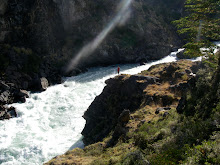
Then we crossed a high scree field across a caldera to reach Paso Beban Oeste (850m), a windy pass looking down the valley towards the Rio Torito Valley and other high peaks. We descended rapidly, starting our decent around 7pm. We passed some beaver dams along the way, creating cascades and pools as we headed down into the valley. Around 8:30 we decided to camp, about 30 minutes short of our destination at Salto Azul.
1/7 - 30 minutes above Salto del Azul to Valley Carbajal, 16km, 8 hours
We broke camp late, around 11:30, another late start. It is really difficult to get the momentum in the morning when its cold, and has been raining a lot. Everyone was cold and getting the group going took some doing. Once we got hiking, we had to follow the river down for 30 minutes to Salto del Azul, then along river for another 1.25km before heading back up the valley towards the Laguna Azul and the next pass. We started to climb a bit early and got really lost. I didn´t think we had gone far enough down the valley to be climbing and the map looked like we were still short of the trail. After climbing for an hour through very thick brush, trees and streams, we got back to the river. We headed downstream in search of the supposed trail, but were unable to find it. Frustrated we headed back up the valley towards the waterfall, completing a big circle of maybe 4-5km. This loop brought us back to where we started around 1:30pm. From here we decided to climb up the valley again, this time heading due south up the steep valley walls. We finally got high enough to orient ourselves in the valley around 2:30pm, but the fog and clouds were so dense, that it was very difficult, if not impossible to navigate.
We continued south and up the valley, resting frequently because of the inclination of the slope. in places, we were climbing 45-60 degree rock and dirt up the valley. We got glances of the surrounding mountains, but couldn´t figure out exactly where we were. Around 4:00pm I decided that we were going to go until 5pm, and if we were still feeling lost we would descend the 600m or so we had climbed from the river and go back to where we had camped the night before. It was a harsh reality, but we couldn´t be starting the crossing at 6pm with 4-5 hours of hiking to be done. I wasn´t willing to take that risk.
We were headed up in search of the Laguna Azul, which was very impossible to find. We came across some small ponds, but nothing that would warrant a Laguna. As we neared a high summit, I said we should go to the top of the ridge, thinking we might have missed the laguna and that this was the pass. We headed up, but at the ridge line, it was clear that we hadn´t found the pass. Regretfully, we began to head down towards the river valley, resigned to the fact that we weren´t going to finish the trek as planned. We stopped to take photos of the cloud-filled valley, joking that we were less than a few hundred meters from the Laguna and couldn´t see it, or that the small, pathetic looking boggy pools below were the Laguna Azul.
As we descended, the sun broke for a second, the clouds cleared, and as I looked north up the valley, I saw something blue. Very blue. It was the Laguna, less than 200m across the ridge. We had found it. We triumphantly traversed the scree slope, heading to the Laguna around 5pm, right at the cutoff time. From the laguna, we could see the pass and the sun was shining. We decided to go for it. Reaching the Paso Mariposa was a trip highlight. From the pass we had a high view of the surrounding mountains, the Laguna Azul and its smaller counterpart, the 4 lakes on the other side of the pass. It was magic.
We glisaded down the scree on the back side toward the Lago Capullo, more than 500m below. We reached an early camp aside the Lake around 7:30pm amongst some large boulders. About 30 minutes later we were treated to a rainbow over Lake Capullo as we made dinner. We stopped 2 hours short of our Camp in the Valley Carbajal as we were all totally worked from the day. I think we walked more than 20km with more than 1500m vertical. It was an exhausting day.
1/8 - 2 hours short of Valley Carbajal to Ruta 3, 16km, 12 hours
We left camp early this day and headed straight back up the valley wall toward the Paso Valdivieso. There was again some discrepancey about which direction we needed to head this morning, but it was pretty clear after close inspection of the Topo and compass. We needed to head south away from the Kami Lake, and from the ridge it was clear which way we needed to go around a large rocky mountain/ ridge. Around 9am we reached a high rib overlooking the 5 lakes below including Kami, the large lake that bisects Tierra del Fuego. Around 11am we crossed Pass Valdivieso and descended towards Lago Valdivieso. This was a steep decent, and 15 minutes down Nadia sprained her ankle, not a good way to start a huge day.
We reached the Valley Floor around noon, with roughly 7 hours of hiking left to finish the circuit out to Ruta 3 and back to Ushuaia. Again, the valley proved unwilling to let us out. As soon as we got to the Rio Olivia Valley, the trails went crazy. The entire valley has been taken over by the pesky North America Beaver, who has managed to flood every part of the valley, fall trees everywhere, and build knee deep pools that make everything that isn´t inundated with water, deep sticky muck. It was a mess. Nadia and I were feeling very worked and had the time to stay another night, so we stopped about 2 hours early while the 2 Israelis headed to Ruta 3 for their bus the next morning. I imagine they arrived in Ushuaia around 11pm.
1/9 - 2 hours short of Ruta 3, 5km
We camped at Lago Arco Iris and were treated with amazing pre-sunrise fog and reflection over the still morning. It was another trek highlight for me. Watching the steam rise over the lake and the cold, stillness that can only be found in the early minutes of the day was relaxing in the cold air.
The rest of the hike out was mellow. We saw a beaver slap its tail in the water as it crossed a pool. Then hiked the rest of the way out to Ruta 3 where we hitched back to Ushuaia and on to the next adventure...
2 comments:
Great trip report. It would be easier to use a GPS in some parts for the routefinding. This is a difficult trekking but really great. We did it 2 times. You can contact me at juanallanos786@yahoo.com.ar to interchange some information.
Thanks for the report! Where did you buy the topo map from, please?
Post a Comment